| 2015-04-20 11:21 |
Wythe (County) |
Rt. 625N (Wythe County) at Crawfish Rd View on Map |
impassable because of flood – Rt. 625N (Wythe County) at Crawfish Rd |
Weather – Flood – Weather |
| 2015-04-20 11:21 |
Wythe (County) |
Rt. 614N (Wythe County) at Ramsey Mountain Rd View on Map |
passable with care because of flood – Rt. 614N (Wythe County) at Ramsey Mountain Rd |
Weather – Flood – Weather |
| 2015-04-20 11:21 |
Wythe (County) |
Rt. 600S (Wythe County) at Rose Hill Rd View on Map |
impassable because of flood – Rt. 600S (Wythe County) at Rose Hill Rd |
Weather – Flood – Weather |
| 2015-04-20 11:21 |
Wythe (County) |
Rt. 650N (Wythe County) at Rudisill Rd View on Map |
impassable because of flood – Rt. 650N (Wythe County) at Rudisill Rd |
Weather – Flood – Weather |
| 2015-04-20 11:21 |
Wythe (County) |
Rt. 664E (Wythe County) at Glade Rd View on Map |
impassable because of flood – Rt. 664E (Wythe County) at Glade Rd |
Weather – Flood – Weather |
| 2015-04-20 11:21 |
Wythe (County) |
Rt. 618N (Wythe County) at Reed Creek Dr View on Map |
passable with care because of flood – Rt. 618N (Wythe County) at Reed Creek Dr |
Weather – Flood – Weather |
| 2015-04-20 11:21 |
Wythe (County) |
Rt. 614S (Wythe County) at Ramsey Mountain Rd View on Map |
passable with care because of flood – Rt. 614S (Wythe County) at Ramsey Mountain Rd |
Weather – Flood – Weather |
| 2015-04-20 11:21 |
Wythe (County) |
Rt. 650S (Wythe County) at Rudisill Rd View on Map |
impassable because of flood – Rt. 650S (Wythe County) at Rudisill Rd |
Weather – Flood – Weather |
| 2015-04-20 11:21 |
Wythe (County) |
Rt. 749E (Wythe County) at Cedar Springs Rd View on Map |
impassable because of flood – Rt. 749E (Wythe County) at Cedar Springs Rd |
Weather – Flood – Weather |
| 2015-04-20 11:21 |
Wythe (County) |
Rt. 664W (Wythe County) at Glade Rd View on Map |
impassable because of flood – Rt. 664W (Wythe County) at Glade Rd |
Weather – Flood – Weather |
| 2015-04-20 11:21 |
Wythe (County) |
VA-121N at Max Meadows Rd View on Map |
impassable because of flood – VA-121N at Max Meadows Rd |
Weather – Flood – Weather |
| 2015-04-20 11:21 |
Wythe (County) |
Rt. 600N (Wythe County) at Rose Hill Rd View on Map |
impassable because of flood – Rt. 600N (Wythe County) at Rose Hill Rd |
Weather – Flood – Weather |
| 2015-04-20 11:21 |
Wythe (County) |
Rt. 619W (Wythe County) at Gleaves Rd View on Map |
impassable because of flood – Rt. 619W (Wythe County) at Gleaves Rd |
Weather – Flood – Weather |
| 2015-04-20 11:21 |
Wythe (County) |
Rt. 715N (Wythe County) at Cobb Rd View on Map |
impassable because of flood – Rt. 715N (Wythe County) at Cobb Rd |
Weather – Flood – Weather |
| 2015-04-20 11:21 |
Wythe (County) |
Rt. 649N (Wythe County) at Kents Ln View on Map |
passable with care because of flood – Rt. 649N (Wythe County) at Kents Ln |
Weather – Flood – Weather |
| 2015-04-20 11:21 |
Wythe (County) |
Rt. 625S (Wythe County) at Crawfish Rd View on Map |
impassable because of flood – Rt. 625S (Wythe County) at Crawfish Rd |
Weather – Flood – Weather |
| 2015-04-20 11:21 |
Wythe (County) |
Rt. 619E (Wythe County) at Gleaves Rd View on Map |
impassable because of flood – Rt. 619E (Wythe County) at Gleaves Rd |
Weather – Flood – Weather |
| 2015-04-20 11:21 |
Wythe (County) |
Rt. 649S (Wythe County) at Kents Ln View on Map |
passable with care because of flood – Rt. 649S (Wythe County) at Kents Ln |
Weather – Flood – Weather |
| 2015-04-20 11:21 |
Wythe (County) |
Rt. 715S (Wythe County) at Cobb Rd View on Map |
impassable because of flood – Rt. 715S (Wythe County) at Cobb Rd |
Weather – Flood – Weather |
| 2015-04-20 11:21 |
Wythe (County) |
Rt. 738S (Wythe County) at Jonas Town Rd View on Map |
impassable because of flood – Rt. 738S (Wythe County) at Jonas Town Rd |
Weather – Flood – Weather |
| 2015-04-20 11:21 |
Wythe (County) |
Rt. 655N (Wythe County) at High Bridge Rd View on Map |
impassable because of flood – Rt. 655N (Wythe County) at High Bridge Rd |
Weather – Flood – Weather |
| 2015-04-20 11:21 |
Wythe (County) |
Rt. 603N (Wythe County) at Cove Rd; Rockdale Rd; Rt. 659E/W (Wythe County); City Rt. 5255N/S (Town of Wytheville); County/City/Town Line: @ WYTHEVILLE View on Map |
impassable because of flood – Rt. 603N (Wythe County) at Cove Rd; Rockdale Rd; Rt. 659E/W (Wythe County); City Rt. 5255N/S (Town of Wytheville); County/City/Town Line: @ WYTHEVILLE |
Weather – Flood – Weather |
| 2015-04-20 11:21 |
Wythe (County) |
Rt. 738N (Wythe County) at Jonas Town Rd View on Map |
impassable because of flood – Rt. 738N (Wythe County) at Jonas Town Rd |
Weather – Flood – Weather |
| 2015-04-20 11:21 |
Wythe (County) |
Rt. 655S (Wythe County) at High Bridge Rd View on Map |
impassable because of flood – Rt. 655S (Wythe County) at High Bridge Rd |
Weather – Flood – Weather |
| 2015-04-20 11:21 |
Wythe (County) |
Rt. 749W (Wythe County) at Cedar Springs Rd View on Map |
impassable because of flood – Rt. 749W (Wythe County) at Cedar Springs Rd |
Weather – Flood – Weather |
| 2015-04-20 11:21 |
Wythe (County) |
Rt. 680W (Wythe County) at Black Lick Rd View on Map |
impassable because of flood – Rt. 680W (Wythe County) at Black Lick Rd |
Weather – Flood – Weather |
| 2015-04-20 11:21 |
Wythe (County) |
Rt. 684S (Wythe County) at Old Bank Rd View on Map |
impassable because of flood – Rt. 684S (Wythe County) at Old Bank Rd |
Weather – Flood – Weather |
| 2015-04-20 11:21 |
Wythe (County) |
Rt. 779N (Wythe County) at Francis Mill Rd View on Map |
passable with care because of flood – Rt. 779N (Wythe County) at Francis Mill Rd |
Weather – Flood – Weather |
| 2015-04-20 11:21 |
Wythe (County) |
Rt. 684N (Wythe County) at Old Bank Rd View on Map |
impassable because of flood – Rt. 684N (Wythe County) at Old Bank Rd |
Weather – Flood – Weather |
| 2015-04-20 11:21 |
Wythe (County) |
Rt. 643N (Wythe County) at Silings Rd View on Map |
impassable because of flood – Rt. 643N (Wythe County) at Silings Rd |
Weather – Flood – Weather |
| 2015-04-20 11:21 |
Wythe (County) |
US-52N at Stoney Fork Rd View on Map |
impassable because of flood – US-52N at Stoney Fork Rd |
Weather – Flood – Weather |
| 2015-04-20 11:21 |
Wythe (County) |
Rt. 603S (Wythe County) at Cove Rd; Rockdale Rd; Rt. 659E/W (Wythe County); City Rt. 5255N/S (Town of Wytheville); County/City/Town Line: @ WYTHEVILLE View on Map |
impassable because of flood – Rt. 603S (Wythe County) at Cove Rd; Rockdale Rd; Rt. 659E/W (Wythe County); City Rt. 5255N/S (Town of Wytheville); County/City/Town Line: @ WYTHEVILLE |
Weather – Flood – Weather |
| 2015-04-20 11:21 |
Wythe (County) |
Rt. 680E (Wythe County) at Black Lick Rd View on Map |
impassable because of flood – Rt. 680E (Wythe County) at Black Lick Rd |
Weather – Flood – Weather |
| 2015-04-20 11:21 |
Wythe (County) |
Rt. 642W (Wythe County) at Pope Rd View on Map |
impassable because of flood – Rt. 642W (Wythe County) at Pope Rd |
Weather – Flood – Weather |
| 2015-04-20 11:21 |
Wythe (County) |
Rt. 643N (Wythe County) at Old School Rd View on Map |
impassable because of flood – Rt. 643N (Wythe County) at Old School Rd |
Weather – Flood – Weather |
| 2015-04-20 11:21 |
Wythe (County) |
Rt. 643S (Wythe County) at Silings Rd View on Map |
impassable because of flood – Rt. 643S (Wythe County) at Silings Rd |
Weather – Flood – Weather |
| 2015-04-20 11:21 |
Wythe (County) |
Rt. 643S (Wythe County) at Old School Rd View on Map |
impassable because of flood – Rt. 643S (Wythe County) at Old School Rd |
Weather – Flood – Weather |
| 2015-04-20 11:21 |
Wythe (County) |
Rt. 642E (Wythe County) at Pope Rd View on Map |
impassable because of flood – Rt. 642E (Wythe County) at Pope Rd |
Weather – Flood – Weather |
| 2015-04-20 11:21 |
Wythe (County) |
US-21S at Grayson Tpke View on Map |
passable with care because of flood – US-21S at Grayson Tpke |
Weather – Flood – Weather |
| 2015-04-20 11:21 |
Wythe (County) |
Rt. 779S (Wythe County) at Francis Mill Rd View on Map |
passable with care because of flood – Rt. 779S (Wythe County) at Francis Mill Rd |
Weather – Flood – Weather |
| 2015-04-20 08:44 |
Wythe (County) |
I-81S from MM 65.0 to MM 57.4 View on Map |
On I-81 in the County of Wythe from mile marker 65 to mile marker 57.4, motorists can expect potential delays in this area from 04/20/15 at 8:42 AM until 04/20/15 at 6:00 PM due to pothole patching operations. The south right shoulder is a mobile closure. |
Planned Event – WZ – Maintenance – Pothole Patching Operations |



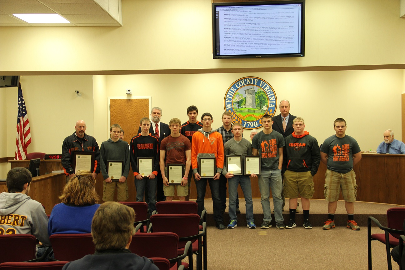
 The Board of Supervisors then voted on Wythe County Resolution 2015-06, “A Resolution Honoring the Rural Retreat High School Wrestling Team.”